Search Term Record
Metadata
Name |
Gov, Arapahoe County |
Related Records
-
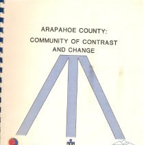
Arapahoe County : community of contrast and change. - Arapahoe County (Colo.)
League of Women Voters (U.S.) Arapahoe Regional Libraries.
Record Type: Library
-
-
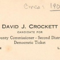
GENL-2016.002.0010 - Card, Political
Political card; tan, rectangular, cardstock political card with black ink text; text on front side only; text reads: "David J. Crockett Candidate for County Commissioner - Second District Democratic Ticket Arapahoe County Littleton, Colo."; handwritten text in pencil along upper edge reads: "Circa: 1908" with 1908 underlined.
Record Type: Object
-
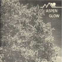
GENL-2016.020.0000a-b - Magazine
a.) Magazine; "Aspen Glow" magazine; forty-eight letter-sized paper pages with black ink typewritten and photocopied text; text on both sides; front cover has black and white photographic image of trees, with magazine logo and "Aspen Glow" in upper right corner; magazine contains fourteen articles; see Notes for article names, along with writers and photographers; articles contain black and white photographic images, hand-drawn diagrams and drawi...
Record Type: Object
-
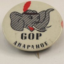
GENL-2016.033.0000 - Button, Campaign
Campaign button; round, off-white plastic button with metal backing and brass colored metal pin; cartoon image of elephant head, wearing American Indian style headband with red feather; elephant is looking to right, with upraised trunk and open mouth; black typewritten text below elephant head reads: " GOP Arapahoe"; red marking on right edge of button.
Record Type: Object
-
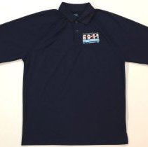
GENL-2018.018.0034 - Shirt, Polo
Polo shirt; navy blue, 100% polyester, polo shirt with embroidered patch on left side of chest, size XL; patch is white text with red line representing pulse/heartbeat, and light blue rectangle below; text of patch reads "Arapahoe County E9-1-1" with red line through E9-1-1, "Emergency Communications Service Authority" in light blue rectangle, and "Fire-Law Enforcement-EMS" at bottom; three navy blue, four hole buttons at neck, with collar around...
Record Type: Object
-
GENL-2018.032.0015 - Plaque
Plaque; brown and bronze, rectangular, wood plaque with blue and white bond document sealed onto face; beveled edges around plaque, with bronze painted edges; white, rectangular, paper bond with gold exterior border, blue decorative border, and black text; top of bond has black text reading "State of Colorado," "United States of America," and "County of Arapahoe"; circular inset at center of top shows drawn image of bald eagle with wings spread; ...
Record Type: Object
-
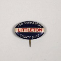
GENL-2024.030.0000 - Button, Campaign
Button; "Littleton For Permanent County Seat" campaign button/pin, c.1904. Button is small in size, blue, white and red in color, and made of metal. Button is oval shaped, with a horizontal orientation. The front of the button is slightly convex. The pin on the back that is used to adhere the button onto clothing is visible from the front and sticks out about 1/4 inch on the bottom edge of the pin. The pin is sharp on the end. Button is dark blue...
Record Type: Object
-
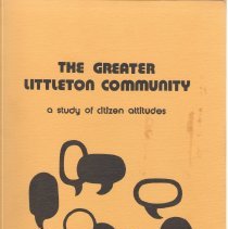
The greater Littleton community : a study of citizen attitudes. - Flaming, Karl H.
Arapahoe Community College.
Record Type: Library
-
XX-0040 - Seal
Small black iron stamp with a red star on either side; seal of South Arapahoe County; handle depresses down, embossing seal from round die; embossing reads: "State of Colorado South Arapahoe County County Court Seal". See accession file for example of embossing. From the exhibit "The Story of Littleton in 125 Objects": South Arapahoe County was formed from the reorganization of land that created the City and County of Denver at the turn of th...
Record Type: Object
-
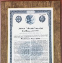
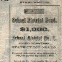
XX-0186.019 - Bond
No. 6 in a series of six bonds for school buildings; "School District Number 6, County of Arapahoe, State of Colorado, $1,000. October 24, 1883. Principal redeemable after September 1, 1888, and payable September 1, 1898."; on parchment paper, with green & black printed text; signed by Joseph W. Bowles, Pres., Board of Directors; stamped "Paid Oct. 1, 1898"; embossed with seal of Arapahoe County, Colorado.
Record Type: Object
-
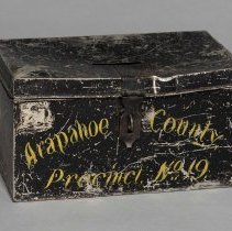
XX-0223 - Box, Ballot
Rectangular tin with black enameled surface; "Arapahoe County, Precinct No. 19" in yellow lettering on side; hinged lid has narrow rectangular cut-out slot at top center; metal loop for attaching padlock on lid. From the exhibit "The Littleton Story in 125 Objects": Little is known about this ballot box, except that it was used in Arapahoe County at Precinct No. 19. It was acquired by the Littleton Historical Society before the formation of th...
Record Type: Object
-
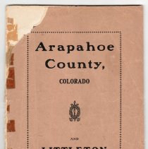
XX-0648 - Booklet
"Arapahoe County, Colorado, and Littleton, Its County Seat"; published by Henry Kraft, 1904; includes a history of the town, schools, and water supply, with photographic images of some of the municipal officers, county officials, and the mayor, in addition to photos of houses, churches, Main Street, and schools; also includes many advertisements; see photocopy of booklet in accession file. NOTE - small pink note on accession card: "Resolve is...
Record Type: Object
-
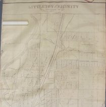
XX-0675 - Map
"Littleton and Vicinity, Arapahoe County, Colorado" Revised March 1949, by Ira Van Dreal, Assessor, J.N. Balleydier, draftsman; scale: 200 feet = 1 inch; large white rectangular paper; see photographic image in accession file; sheet attached in upper left corner which explains the tax base.
Record Type: Object
-
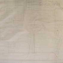
XX-0676 - Map
"The Town of Sheridan and Vicinity, Arapahoe County" Revised January 1949, by Ira Van Dreal, Assessor, J.N. Balleydier, draftsman; scale: 200 feet = 1 inch; see photographic image in accession file.
Record Type: Object
-
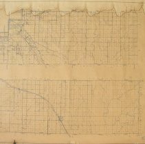
XX-0677 - Map
"Arapahoe County, Colorado"; prepared by the Colorado State Highway Department in cooperation with the U.S. Department of Agriculture Bureau of Public Roads; data obtained from State-wide Highway Planning Survey, 1936; scale: 1 inch = 1 mile.
Record Type: Object
-
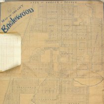
XX-0678 - Map
"Map of the City Englewood, Arapahoe County, Colorado", Revised April 1932; C.E. Watlington, assessor, Littleton "Mack"; from April 1912 map, F.D. Lewis, assessor; scale: 1 inch = 200 feet; see photographic image of map in accession file; blue ink printing.
Record Type: Object
-
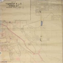
XX-0679 - Map
"Map of Township 4 And 5, Range 67, Arapahoe County, Colorado", Revised January 1, 1954"; Ira Van Dreal, Assessor; off-white rectangular paper with black printing and red and blue accents; scale: 1 inch = 200 feet; see photographic image in accession file.
Record Type: Object
-
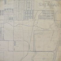
XX-0680 - Map
"The Town of Sheridan and Vicinity, Arapahoe County"; off-white rectangular paper with blue printing; scale: 1 inch = 200 feet; see photographic image in accession file.
Record Type: Object
-
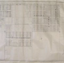
XX-0681 - Map
"Map of Aurora, Arapahoe County, Colorado", January 1944; white rectangular paper map with blue printing; Walter W. Hanson, Assessor; scale: 1 inch = 200 feet; see photographic image in accession file.
Record Type: Object