
Object Record
Images
Metadata
Object ID |
XX-0679 |
Object Name |
Map |
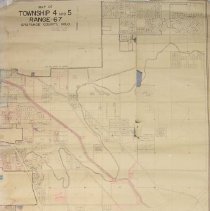
Description |
"Map of Township 4 And 5, Range 67, Arapahoe County, Colorado", Revised January 1, 1954"; Ira Van Dreal, Assessor; off-white rectangular paper with black printing and red and blue accents; scale: 1 inch = 200 feet; see photographic image in accession file. |
Date |
1954 |
Caption |
XX-0679, Map, "Map of Township 4 And 5, Range 67, Arapahoe County" 1954 |
Search Terms |
Gov, Arapahoe County |